~SOLAR SYSTEM ON~
GALAXIES
Galaxies

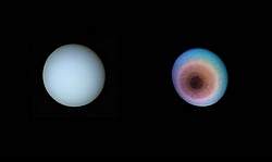
Title: Uranus
Caption: Two images of Uranus one in natural color, the other in false color. The natural color image, on the left, is how Uranus would appear to the human eyes. The false color image has been processed so as to reveal changes, and features, that are not normally apparent. The blue-green appearance of the planet is due to the presence of methane in the atmosphere, which absorbs red light. The banding structure seen in the false color image is real, although the differences are exaggerated. The dark polar spot could be due to a polar haze created by ultraviolet light reacting with the methane in the atmosphere.
Copyright:(c) Public Domain
Credit: NASA/JPL
<< Back <<
Title: Thin Crescent of Uranus
Caption: The thin crescent of Uranus seen at an angle of 153° between the spacecraft, the planet and the Sun. Even at this extreme viewing angle Uranus still exhibits its characteristic blue-green hues. The whitening near the edge is caused by the presence of high altitude haze.
Copyright:(c) Public Domain
Credit: NASA/JPL
<< Back <<
Title: Clouds on Uranus
Caption: These two false-color Hubble Space Telescope images of Uranus were taken 90 minutes apart. The blue colors probe deepest into the atmosphere. A blue color indicates clear atmospheric conditions, visible around the equator. The green color indicates a clear atmosphere, which is free from cloud, but contains a thin misty haze. The red exposure reveals absorption by hydrogen. Several clouds are visible in both images and their motion can easily be seen between the two. Also visible are eight of the ten small Uranian satellites. They range in size from 40 km (25 miles) for Bianca to 150 km (100 miles) for Puck.
Copyright:(c) Public Domain
Credit: STScI-PRC97-36A, Erich Karkoschka (University of Arizona), NASA
<< Back <<
Title: Uranus' Atmosphere
Caption: A Hubble Space Telescope image reveals three layers of features in Uranus' atmosphere. The thin purple-red edge to the planet corresponds to very thin haze at high altitude. The yellow near the bottom of Uranus is another hazy layer. The deepest layer, the blue near the top, shows a clearer atmosphere. Image processing has been used to brighten the rings around Uranus to enable the structure to be studied.
Copyright:(c) Public Domain
Credit: STScI-PRC96-15, Erich Karkoschka (University of Arizona), and NASA
<< Back <<
Title: Rings and Moons
Caption: Two shepherd satellites, associated with the rings of Uranus, were discovered by Voyager 2. The two moons are seen either side of the bright epsilon ring; all nine of the known rings are visible. The epsilon ring appears surrounded by a dark halo. This is an artifact that has occurred as a result of image processing. The rings range in width from about 100 km (60 miles) in the epsilon ring to just a few kilometers in the others. The presence of the two moons has almost stopped the rings spreading out further.
Copyright:(c) Public Domain
Credit: NASA/JPL
<< Back <<
Title: Ring System
Caption: An interesting Voyager 2 image reveals a continuous distribution of small particles throughout the Uranus ring system. The image was taken at a unique geometry, from within the shadow of Uranus, and allows astronomers to see lanes of fine dust not visible from other viewing angles.
Copyright:(c) Public Domain
Credit: NASA/JPL
<< Back <<
Title: Satellites of Uranus
Caption: Voyager 2 discovered several new moons in orbit around Uranus. This image shows three that all lie outside the orbit of the known rings of Uranus. The largest moon shown here, 1986U1, is about 90 km (55 miles) across and orbits Uranus in about 12 hours. Because these moons are so tiny, and therefore faint, long exposures are required to image them, causing them to blur in the image.
Copyright:(c) Public Domain
Credit: NASA/JPL
<< Back <<

Miranda

Title: Miranda
Caption: Mosaic of high-resolution images of Miranda reveals another rocky, cratered world. Also visible on this image are ridges, valleys and a number of highly reflective regions. This image is centered on the south pole and comprises both wide and narrow angle views.
Copyright:(c) Public Domain
Credit: NASA/JPL
<< Back <<
Title: South Polar View
Caption: A full disc south polar view of Miranda reveals its varying geologic features. There are two major types of very different terrain revealed in this image. One is an older, heavily cratered and rolling terrain. The other is a young, complex terrain characterized by sets of bright and dark bands, scarps and ridges.
Copyright:(c) Public Domain
Credit: NASA/JPL
<< Back <<
Title: High Resolution Mosaic
Caption: Miranda is a moderate sized moon, about 500 km (300 miles) in diameter, yet it contains many varied landforms. These images are among the highest resolution images ever returned from a foreign world. Ridges and valleys of one region are cut off against the boundary of the next region. Some regions show very large scarps, or cliffs, ranging from 0.5 to 5 km (0.3 to 3 miles) in height.
Copyright:(c) Public Domain
Credit: NASA/JPL
<< Back <<
Title: Grooved Surface
Caption: A close up view of the surface of Miranda that reveals a strange v-shaped feature and regions of very different terrain. Grooved areas, of light and dark bands, are very different to the other areas of mottled terrain. Scientists are still uncertain as to what causes such a complex terrain to form.
Copyright:(c) Public Domain
Credit: NASA/JPL
<< Back <<
Title: Fractures, Grooves and Craters
Caption: A high-resolution, 600 m (2,000 feet), image reveals a panoply of surface fractures, grooves and craters as well as features of different reflectance. The grooves and troughs reach depths of a few kilometers and expose different materials. This great variety of features implies a long, complex geological evolution for Miranda.
Copyright:(c) Public Domain
Credit: NASA/JPL
<< Back <<

Ariel

Title: Ariel at Closest Approach
Caption: Ariel is another tiny world in the Solar System, being just 1,300 km (800 miles) in diameter. The complex view of the surface indicates that a range of geologic processes have occurred. The high number of craters indicates a long period of surface bombardment. Also visible at this resolution are linear grooves, evidence for tectonic activity, and smoother patches, evidence for deposition of material.
Copyright:(c) Public Domain
Credit: NASA/JPL
<< Back <<
Title: Ariel's Surface
Caption: A mosaic of four high-resolution frames reveals the most detailed pictures of Ariel. Ariel is about 1,300 km (800 miles) in diameter. Much of Ariel's surface is covered in densely pitted craters 5 to 10 km (3 to 6 miles) across. Many valleys and scarps are seen to cross the terrain. The largest fault valleys, near the terminator, as well as a smooth region in the middle, have been partially filled with young deposits.
Copyright:(c) Public Domain
Credit: NASA/JPL
<< Back <<
Title: Color View of Ariel
Caption: A color mosaic of views of the Uranian moon Ariel. The resolution of the resulting image is roughly 3 km (2 miles). Most of the visible surface is covered by cratered terrain scared by faults and valleys. Some of the largest valleys are filled with young deposits that appear less heavily cratered.
Copyright:(c) Public Domain
Credit: NASA/JPL
<< Back <<

Titania

Title: Titania
Caption: A full-disk view of Titania at a resolution of 9 km (6 miles). Many circular depressions are visible and probably relate to impact craters. Other bright patches show radiating rays and are probably relatively recent impact craters. Of greater interest are the linear troughs that are probably fault canyons, possibly associated with tectonic activity.
Copyright:(c) Public Domain
Credit: NASA/JPL
<< Back <<
Title: Titania at High Resolution
Caption: A high-resolution view of Titania, the largest satellite of Uranus with a diameter of 1,600 km (1,000 miles). Its surface is covered in many craters of varying sizes. The most prominent features are fault valleys that stretch across Titania. They are up to 1,500 km (1,000 miles) in length and up to 75 km (45 miles).
Copyright:(c) Public Domain
Credit: NASA/JPL
<< Back <<